|
|
|
Declassified Photos Show Bush Global Warming Cover Up
Posted by Pile
(17102 views)      [E-Mail link] [E-Mail link]
|
[Environment]
 |
 The Obama Administration recently declassified about 1,000 satellite photographs of Arctic ice the Bush Administration had kept under wraps. The photos didn?t make much of a splash until recently, when two English newspapers, the Guardian and the Daily Mail, published some startling examples of the effects of global warming and how the Bush administration sought to cover this up. The Obama Administration recently declassified about 1,000 satellite photographs of Arctic ice the Bush Administration had kept under wraps. The photos didn?t make much of a splash until recently, when two English newspapers, the Guardian and the Daily Mail, published some startling examples of the effects of global warming and how the Bush administration sought to cover this up. |
 |
Graphic images that reveal the devastating impact of global warming in the Arctic have been released by the US military. The photographs, taken by spy satellites over the past decade, confirm that in recent years vast areas in high latitudes have lost their ice cover in summer months.
The pictures, kept secret by Washington during the presidency of George W Bush, were declassified by the White House last week. President Barack Obama is currently trying to galvanize Congress and the American public to take action to halt catastrophic climate change caused by rising levels of carbon dioxide in the atmosphere.
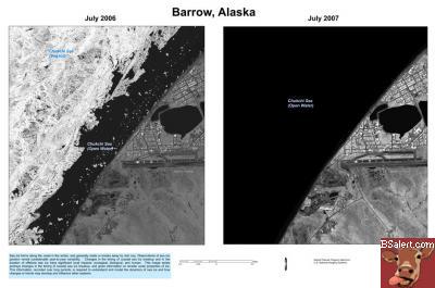
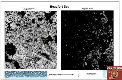
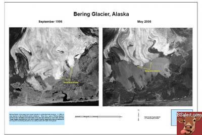
One particularly striking set of images - selected from the 1,000 photographs released - includes views of the Alaskan port of Barrow. One, taken in July 2006, shows sea ice still nestling close to the shore. A second image shows that by the following July the coastal waters were entirely ice-free.
The photographs demonstrate starkly how global warming is changing the Arctic. More than a million square kilometers of sea ice - a record loss - were missing in the summer of 2007 compared with the previous year.
Nor has this loss shown any sign of recovery. Ice cover for 2008 was almost as bad as for 2007, and this year levels look equally sparse.
"These are one-meter resolution images, which give you a big picture of the summertime Arctic," said Thorsten Markus of Nasa's Goddard Space Flight Center. "This is the main reason why we are so thrilled about it. One-meter resolution is the dimension that's been missing."
Disappearing summer sea ice poses considerable dangers, scientists have warned. Ice shelves are used by animals such as polar bears as platforms for hunting seals and other sea creatures. Without them, they could starve. In addition, ice reflects solar radiation. Without that process, the Arctic sea could warm up even more. The phenomenon threatens to set off runaway heating of the planet, say climatologists.
The latest revelations have triggered warnings from scientists that they no longer have the funds to keep a comprehensive track of climate change. Last week the head of the US's National Oceanic and Atmospheric Administration (NOAA), Professor Jane Lubchenco, warned that the gathering of satellite data - crucial to predicting future climate changes - was now at "great risk" because America's aging satellite fleet was not being replaced.
"Our primary focus is maintaining the continuity of climate observations, and those are at great risk right now because we don't have the resources to have satellites at the ready and taking the kinds of information that we need," said Lubchenco, who was appointed by Obama. "We are playing catch-up."
Even before her warning, scientists were saying that America, the world's scientific superpower, was virtually blinding itself to climate change by cutting funds to the environmental satellite programs run by the Oceanic and Atmospheric Administration and Nasa. A report by the National Academy of Sciences this year warned that the environmental satellite network was at risk of collapse.
In February, a Nasa satellite carrying instruments to produce the first map of the Earth's carbon emissions crashed near Antarctica only three minutes after lift-off.
The satellite would have measured carbon emissions at 100,000 points around the planet every day, providing a wealth of data compared to the 100 or so fixed towers currently in operation in a land-based network.
The NOAA is under additional pressure to provide environmental data because of the re-emergence of the El Ni?o climate phenomenon, where warming of the tropical Pacific causes heatwaves, droughts and flooding around the world. June's land and sea surface temperatures were the second hottest on record, and scientists are predicting this will be the warmest decade in recorded history. The last major El Ni?o was in 1998, the hottest year in recorded history. |
Details |
|
|
|


 Bumper Sticker Store